
Written by Carlos Mendoza, maritime historian and travel writer with 12 years covering South American geography and exploration routes.
You’ve probably heard the name. Maybe in a history class, maybe on a documentary about the age of sail. But if you’ve ever tried to actually understand the Strait of Magellan — where it is, why it matters, how it works — you know how quickly most sources either go too shallow or too academic.
This article cuts through that. Whether you’re a traveler planning a trip to the southern tip of South America, a student researching maritime history, or just someone who wants to finally understand what all the fuss is about, you’ll leave here with a clear, complete picture.
What Is the Strait of Magellan?
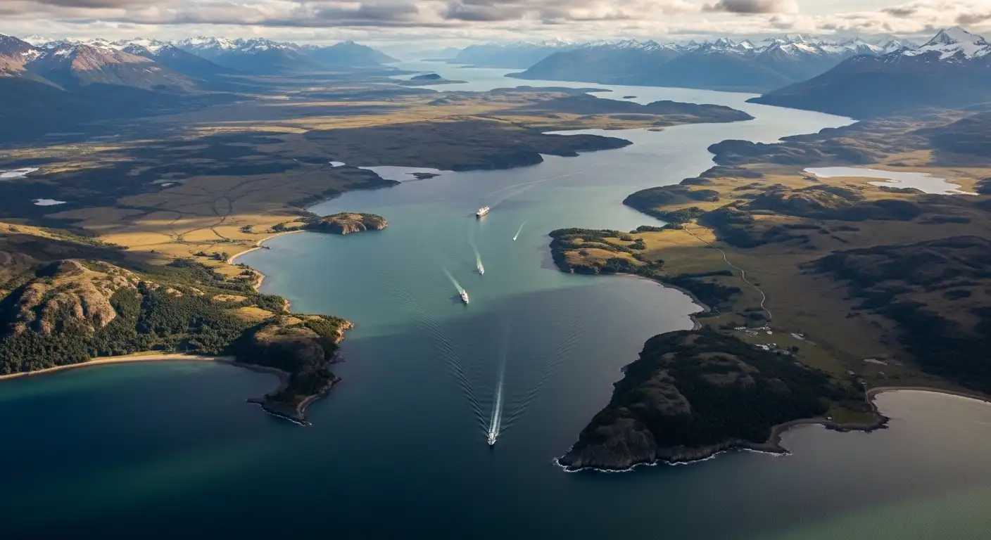
The Strait of Magellan is a natural waterway that cuts through the southern tip of South America, connecting the Atlantic Ocean on the east to the Pacific Ocean on the west. It runs approximately 570 kilometers (354 miles) in length, with widths ranging from just 2.2 kilometers at its narrowest point to about 32 kilometers at its widest.
The strait separates mainland Chile to the north from Tierra del Fuego — an archipelago of islands — to the south. It sits roughly between 52°S and 54°S latitude, placing it firmly in one of the most remote, wind-battered corners of the planet.
The key thing to understand: this is not a calm, gentle channel. It’s a dramatic geological feature where two oceans collide, tides surge unpredictably, and weather can shift from clear to violent in under an hour.
The Story Behind the Name: Magellan’s 1520 Crossing
Imagine sailing in 1520. No GPS. No reliable charts. No guarantee the ocean you’re looking for is even on the other side.
That was Ferdinand Magellan’s reality when his fleet entered the eastern mouth of the strait on October 21, 1520, during the first circumnavigation of the Earth. He spent 38 days navigating the twisting, fog-choked passage before emerging into what he called the “peaceful sea” — the Pacific Ocean.
His fleet entered with five ships. One was wrecked, one turned back to Spain in mutiny. Three continued. The crossing was so brutal and uncertain that his crew nearly abandoned the mission multiple times.
What Magellan found changed everything. Before his crossing, European navigators had no confirmed route from the Atlantic to the Pacific in the Southern Hemisphere. His discovery gave Spain a westward path to Asia and permanently altered global trade and exploration.
The strait was named after him by surviving crew members — a rare honor, given that Magellan himself died in the Philippines before completing the journey.
How to Navigate the Strait of Magellan: A Step-by-Step Overview
Whether you’re a sailor, a cruise passenger, or planning a visit to Punta Arenas (the main city on the strait), here’s how navigation of this waterway actually works today:
- Enter from the Atlantic side via the Primera Angostura (First Narrows), the eastern entrance near the Argentine border. Tidal currents here run strong — up to 8 knots — so timing matters.
- Pass through the Primera and Segunda Angostura (First and Second Narrows). These are the tightest, most technically demanding sections. Large vessels require a Chilean maritime pilot on board by law.
- Navigate the central section through a wider, more sheltered stretch passing near Punta Arenas. This is where most cruise ships pause and passengers often see Magellanic penguins, sea lions, and albatross.
- Enter the western channels, which are more complex — branching fjords, unpredictable winds called williwaws (sudden violent gusts off the mountains), and limited anchorage options.
- Exit into the Pacific near Cape Pilar at the western mouth. At this point, you’re in open ocean — and conditions can deteriorate fast.
Mandatory Chilean pilotage applies to all vessels over 500 gross tons throughout the entire strait. No exceptions.
Joga Directa: The Complete Guide for Football Fans
Common Mistakes People Make About the Strait of Magellan
A lot of misconceptions float around this topic. Here are the ones worth correcting:
- “It’s safer than Cape Horn” — Partially true, but dangerously oversimplified. The strait avoids the open Drake Passage, but its internal hazards (currents, winds, shallow spots, weather) make it no casual shortcut. Many vessels have been lost here too.
- “Magellan discovered it” — Indigenous Fuegian peoples, including the Selknam and Yaghan, had lived on its shores for thousands of years. Magellan was the first European to document and navigate it, not the first human to know it existed.
- “It’s always icy and frozen” — The strait itself doesn’t freeze. Its latitude keeps it ice-free year-round, unlike the waters further south near Antarctica.
- “It’s no longer used” — Modern supertankers do prefer the Panama Canal, but the Strait of Magellan still handles significant commercial traffic, particularly vessels too large or carrying cargo incompatible with Panama’s locks.
- “Punta Arenas is a small outpost” — It’s actually a city of over 130,000 people, with a functioning port, airport, and UNESCO-listed cemetery. It’s a real destination, not just a waypoint.
Strait of Magellan vs. Drake Passage vs. Panama Canal
These three routes all connect the Atlantic and Pacific, but they serve very different needs:
| Feature | Strait of Magellan | Drake Passage | Panama Canal |
|---|---|---|---|
| Location | Tip of South America | Below Cape Horn | Central America |
| Length | ~570 km | ~800 km open ocean | ~80 km |
| Weather | Difficult but manageable | Extremely violent | Tropical, stable |
| Tidal complexity | High | Moderate | Controlled (locks) |
| Open to all vessels? | Yes (with pilot) | Yes | Size-limited |
| Time to transit | 1–3 days | 3–5 days | 8–10 hours |
| Historical significance | First European crossing 1520 | Magellan’s feared alternative | Opened 1914 |
The insight most articles miss: The Strait of Magellan isn’t just a historical footnote or a backup route. For vessels carrying hazardous materials — certain chemicals, LNG tankers — the Panama Canal prohibits transit. The Magellan strait becomes not just an option but the only legal route. That gives it ongoing geopolitical and commercial relevance that few casual readers know about.
Pro Tips for Visiting or Researching the Strait of Magellan
- Best time to visit Punta Arenas: November to March (Southern Hemisphere summer). Days are long, wildlife is active, and cruise frequency peaks.
- Expect wind — always. Punta Arenas averages wind speeds that would be considered a weather event elsewhere. Pack accordingly.
- The free zone: Punta Arenas has long-held duty-free status, making electronics and imported goods noticeably cheaper than the rest of Chile.
- Wildlife highlight: Magdalena Island, accessible by short ferry from Punta Arenas, hosts a Magellanic penguin colony of over 120,000 birds during breeding season.
- For researchers: The Chilean Navy’s hydrographic service publishes detailed nautical charts of the strait — far more accurate than generic mapping tools.
Frequently Asked Questions
How long does it take to sail through the Strait of Magellan?
For a commercial vessel, a full transit typically takes between 24 and 36 hours under normal conditions. Smaller sailing yachts may take 2–4 days depending on weather and anchorage stops.
Is the Strait of Magellan in Chile or Argentina?
It’s primarily in Chilean territory. The eastern entrance briefly borders Argentina, but Chile controls and administers the waterway, including the mandatory pilotage requirement.
Why did sailors fear the Strait of Magellan historically?
The combination of narrow passages, unpredictable tidal surges, sudden williwaw winds, poor visibility, and total isolation made it terrifying for wooden sailing vessels with no weather forecasting. Running aground meant death.
Can tourists cruise through the Strait of Magellan today?
Yes. Several cruise lines operate routes specifically through the strait, including multi-day expeditions between Punta Arenas and Ushuaia (Argentina). It’s a popular route for Antarctic expedition cruises.
What language is spoken and what currency is used near the strait?
Spanish is the primary language. Chilean peso is used in Punta Arenas and throughout Chilean Patagonia. On the Argentine side near Ushuaia, Argentine peso applies.
The Strait of Magellan Still Deserves Your Attention
The Strait of Magellan isn’t just a geography lesson frozen in 1520. It’s an active maritime corridor, a wildlife destination, and one of the most dramatic natural features on Earth — still shaping trade routes and travel itineraries today.
If you’re planning to visit southern Patagonia, build Punta Arenas into your itinerary rather than just passing through it. And if you’re studying global shipping or maritime history, don’t treat this passage as a solved problem — its complexity keeps it relevant in ways most people overlook.